Friday February 1 CSL Meeting
Jan 31, 2019 - CSL

Nicole Casamassina
Spatial Analysis of Ship Traffic in the North Atlantic Ocean during Severe Weather from March 12–19, 2018
Presenter: Nicole Casamassina
Time: Friday 1 February, 2:00-3:00 p.m.
Location: 805 O&M
Abstract: The National Weather Service Ocean Prediction Center (OPC) issues text and graphical analyses and forecasts to warn mariners of hazardous weather conditions such as hurricane force winds, storms, gales, and freezing spray to vessels operating in the high seas areas of the North Atlantic and North Pacific Oceans. High Seas text warning and forecast bulletins are transmitted every 6 hours via satellite transmission as part of the Global Maritime Distress and Safety System (GMDSS). However, the present method of transmitting essential marine weather information, primarily by text bulletins, can be difficult for navigators to interpret and make decisions to keep themselves and their vessels safe. There are recent examples of vessels sailing into hazardous conditions.
In recent years, the OPC has been trying to find the best way to understand how vessels operating on the high seas practice avoidance of heavy and extreme weather warnings and forecasts. Using the Geographic Information System (GIS) software ArcMap 10.4, polygons were created from the text high seas forecasts to get a visual representation of the upcoming weather events near the east coast of the United States in the North Atlantic Ocean from 31°N to 67°N. This project uses data from Automatic Identification Systems (AIS), a ship location tracking system primarily used for maritime collision avoidance. The AIS data is used to determine ship locations during a major winter and ocean storm, along with several smaller systems that moved into the same area from 0000 UTC March 12, 2018 to 1800 UTC March 19, 2018. Ship locations and movements are compared to warning criteria polygons. By looking at ship tracks before and after the forecast is issued, the information can show whether vessels practiced avoidance by moving away from the warned areas. The analysis presented here can be built upon and used to better understand avoidance practices and criteria used by vessel operators in the face of hazardous weather.
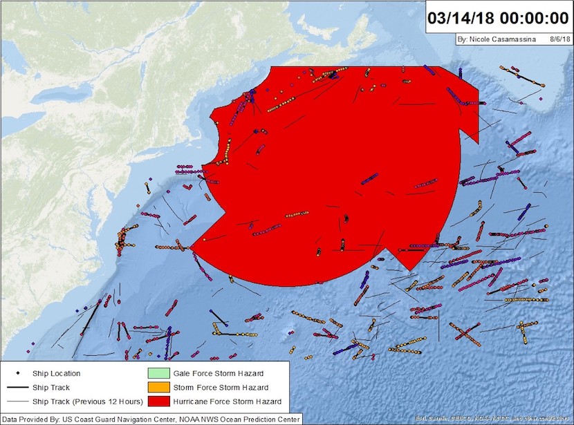 Ships are practicing avoidance southeast of the polygon and there is a gap in the center of the polygon.